While snowfall prospects look somewhat bleak this winter amid the persistent warmth associated with a strong El Niño, there’s still the potential for a big storm if the right ingredients come together at just the right time.
Each month, the European modeling system releases a six-month outlook based on an average of more than four dozen model simulations. The result offers a broad picture of expected weather patterns over the coming months.
The latest outlook holds few major surprises, but reinforces why this winter will be worth watching closely. Adding to the intrigue is a signal for above-average snowfall during a month known for producing some of the region’s biggest storms.
Warm and wet set in stone?
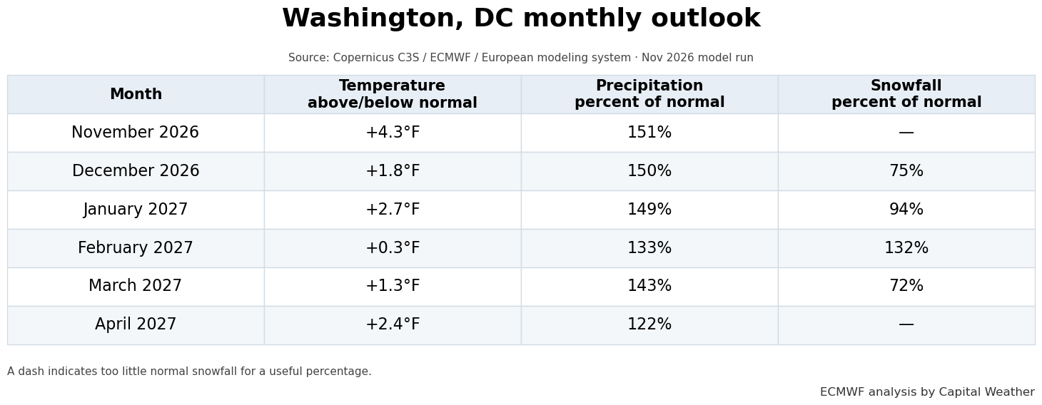
If you’ve been following our winter coverage, it probably comes as no surprise that a warm, wet winter is favored. That’s what our forecast calls for, and we’re hardly alone.
Forecasters across much of the country, particularly along both coasts south of the 45th parallel, favor wetter-than-normal conditions given the strong El Niño. Combined with the long-term warming trend from climate change, many also expect a warmer-than-average winter.
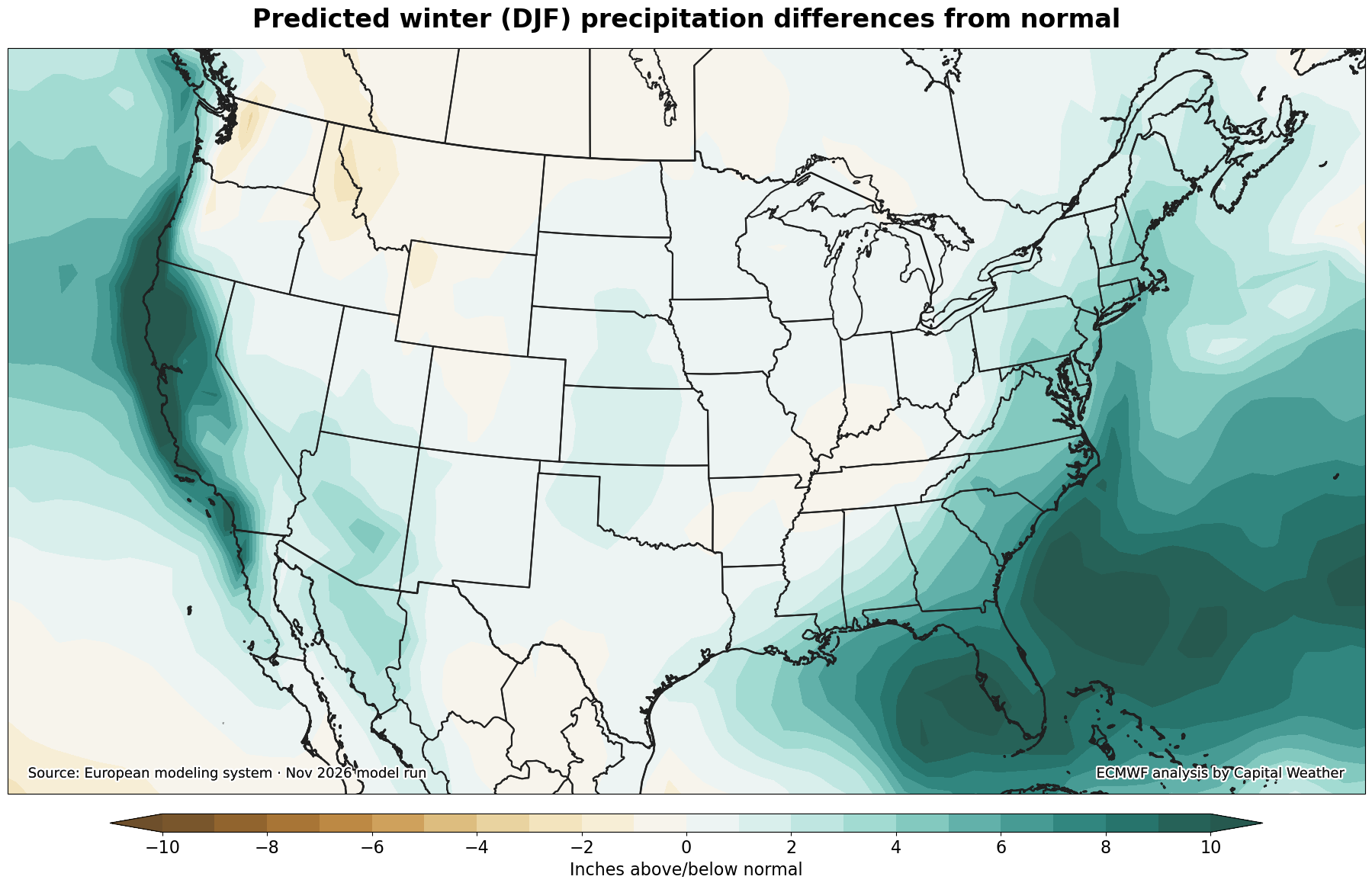
The latest European model outlook projects wetter-than-normal conditions every month from November through April. For the meteorological winter period of December through February, it forecasts precipitation across the Mid-Atlantic and broader East Coast to run at least an inch or two above average, and considerably more in some areas.
Despite the wet outlook, snowfall projections are less encouraging. Most of the core winter months show somewhat below-average snowfall, although January is close to normal and February stands out as snowier than average. A similar pattern appeared in last month’s outlook from the same model.
A snow drought winter with a snowy twist?
One essential ingredient for snow is precipitation, so the prospect of an unusually wet winter offers at least some reason for snow lovers to remain hopeful. Of course, whether that precipitation falls as rain or snow depends heavily on the availability of cold air.
As in last month’s outlook, the European model highlights February as a potentially favorable period for snow. That’s especially intriguing because February has historically produced some of the region’s biggest snowstorms.
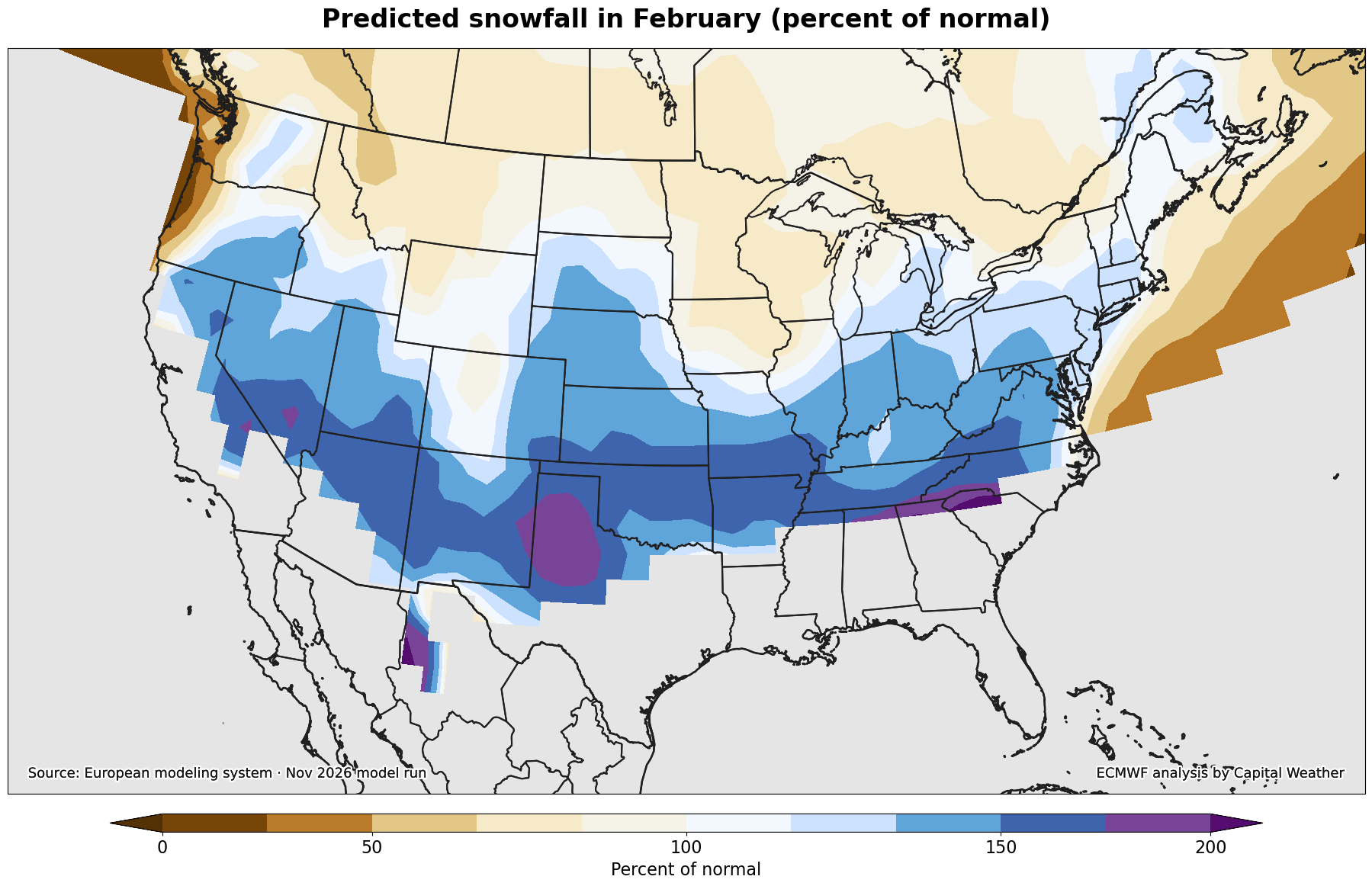
The latest maps show above-average snowfall for the DC region and Mid-Atlantic during the month, raising the possibility that even a generally mild winter could deliver a memorable storm.
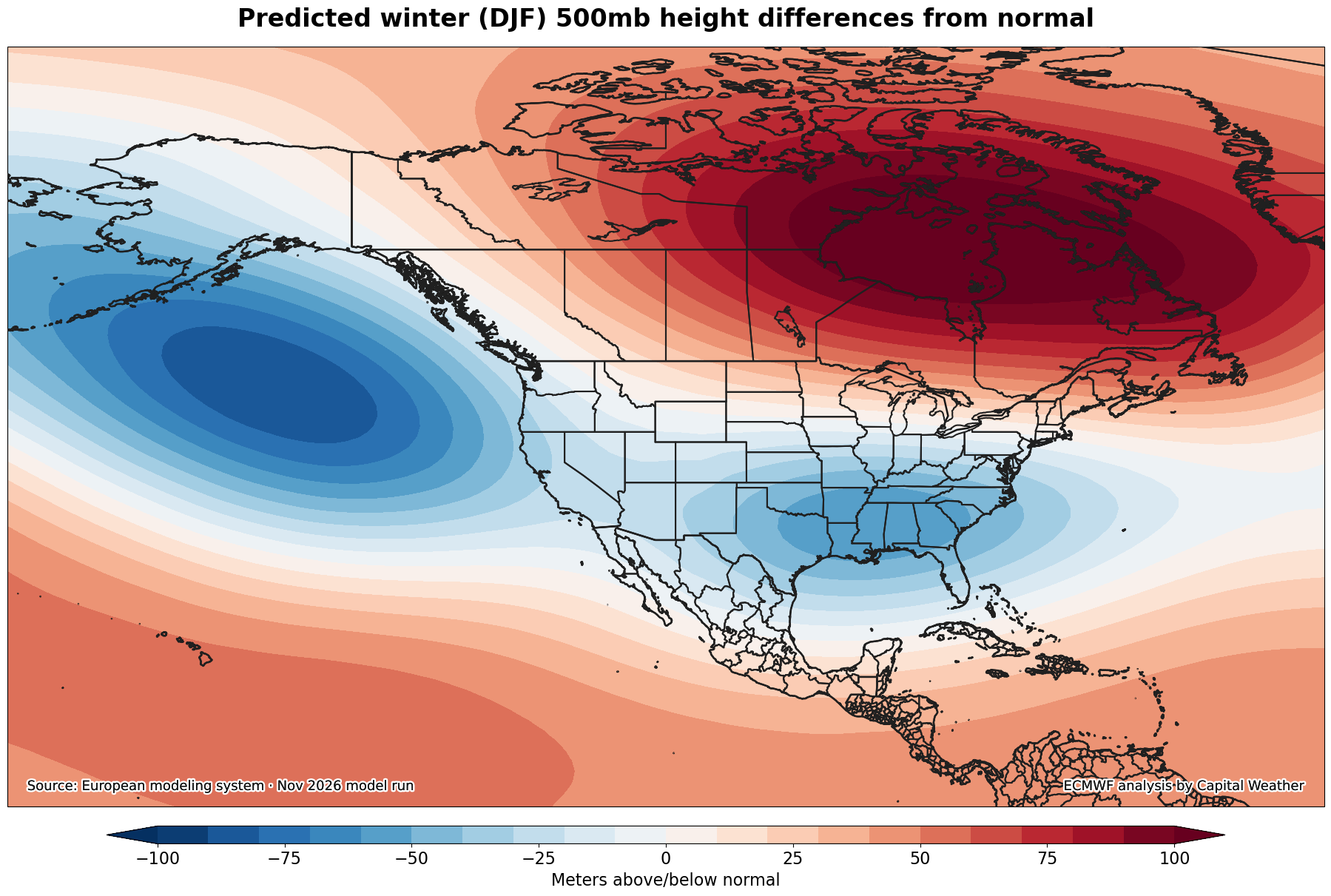
One factor supporting that possibility is the model’s forecast of strong high pressure extending from the Hudson Bay region toward western Greenland. Such a pattern can help steer cold air into the eastern United States and create conditions favorable for East Coast snowstorms.
The projected setup isn’t quite ideal for a major storm in our region, but it resembles a pattern that has accompanied some of DC’s most memorable snow events.
Analogs highlight boom and bust potential
To explore what these projected patterns might mean, we ran the model output through an analog decoder, which searches weather records dating to 1940 for similar atmospheric setups.
The results offer another thought-provoking glimpse of the possibilities for the heart of winter.
January’s top handful of analogs lean cold, with patterns resembling those observed during recent El Niño winters, including 2010 and 2016.
February’s matches, meanwhile, span an extraordinary range: from 2010, one of DC’s snowiest Februarys, to 1998, one of its least snowy. That’s quite a spread — and a reminder of just how different the outcomes can be, even when the broader atmospheric patterns look similar.
Analogs aren’t especially reliable predictors on their own, but they illustrate the potential for dramatic swings during an El Niño winter. The unusual jet stream patterns that can develop during such winters sometimes create opportunities for major snowstorms, even when the season as a whole is relatively mild.
Ultimately, small differences in the position and timing of weather systems can separate a blockbuster snowstorm from a cold rain or a near miss.
That’s what makes this winter so intriguing. The overall outlook may not favor much snow, but it doesn’t rule out a big one. We’ll be watching closely to see whether the pieces come together.
Published Date : 2026-11-07 13:05:00
Source : www.capitalweather.com